Wednesday, April 3, 2013
Return to San J
Well, if the weather holds and the trails clear a bit, it looks like we're going to try to summit San J at the end of this month. Rather than using the Tram like we did last year, we'll be starting at Humber Park for a 16 mile round trip trek. Let the training begin!
Monday, April 1, 2013
Check your gear!
OK, so I jinxed myself apparently when I wrote about my ritual of getting ready before hikes. As I mentioned in my last trail report, my not securing a lanyard to my GPS case meant that my GPS is now up on the side of Tahquitz Peak, or in someone else's pocket (enjoy it if you have it). The legend of Tahquitz's curse of that mountain lives on.
I almost always forget something. Usually it is my Adventure Pass for parking or something else pretty insignificant, but sometimes even the small stuff can take on new significance at 8000 feet and above. And I haven't even started backpacking or overnight trips. Woe to me if I forgot my Via packets on a trip like that.
I've also learned to check gear pretty soon after a hike or outing. Nothing like a moldy water reservoir to get that point across!
I guess I need to get into checklists.
How do you prepare? Let me know in the comments.
Tahquitz Valley via Devil's Slide

My hiking partner is recovering from a broken leg, pretty much the same injury we saw during March madness the other night, and we've been hiking together as he gains his strength. He's usually pretty hard core, so this is a rare chance for me to be able to keep up with him.
The rangers and volunteers we met at the Ranger Station and on the Devil's Slide trail warned us of the snow we'd encounter on both routes, so we headed off to Tahquitz, via the PCT and decided we'd take conditions as we found them and return if it got too hairy.

But I get ahead of myself.
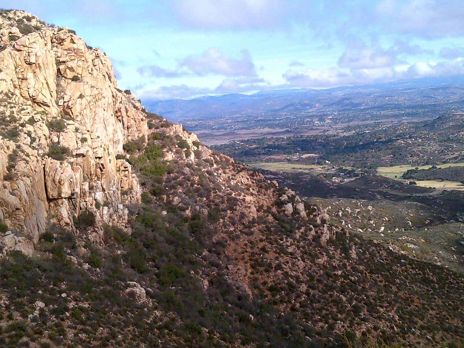
The walk up the Slide was a quick one. Just over an hour to get up 2.5 miles. Once at Saddle Junction and having encountered minimal snow, we headed out on the PCT towards Tahquitz. It was already a warm, cloudless day and we were really enjoying the scenery.
We finally hit snow around 8300 feet, but it was pretty spotty and we still didn't need our Micro Spikes.
At the Tahquitz junction we could see tracks heading out on the usual trail as well as some that look like they went straight up into the snow. We also ran into a lone hiker who asked to tag along. So off we went, inching our way along the side of Tahquitz. About a tenth of a mile in, we hit a shady spot and ice, so we decided it was time for the spikes. After another tenth of a mile and lots of postholing, we decided that was enough.
Lunch break.
The shot above are our tracks, which we followed back to the junction, as seen below.

Things were pretty routine from there until I discovered my GPS was missing. Damn if I had neglected to string up a safety lanyard to it before setting off. So I hiked back up to the junction (I guess I needed the extra mileage) to see if I left it out during our break there.
No luck and there was no way I was heading back out into the snow by myself, so I chalked it up to Tahquitz curse.
On the way back I was rewarded with a beautiful run off/melt water waterfall we had missed on our way up. It was beautiful and calming and reminded my why I hike. I also remembered my GPS was a used basic model from Craig's List, so the rest of the way down was calm and uneventful.
I did stop by the ranger station to file a lost gear report. We'll see if someone finds it out there when the snow really melts away.
It was a beautiful walk on a warm, sunny day. And time in the mountains of southern California is never wasted!
Saturday, March 30, 2013
Getting ready to hike
Does anyone else turn preparing for a hike into a small ritual? Maybe it is my ADHD (I'm not just jumping on a bandwagon here, I've had it since childhood - a LONG time ago), which means I inevitably end up forgetting something. Maybe it is timed to psych myself up for the hike ahead.
I don't know exactly.
But it has become a comfortable night before and morning of ritual. Preparing and cleaning gear. Planning out evening and morning meals for maximum nutrition. Checking maps, weather reports and trail reports for the proposed route. Laying out the clothes for the hike and then piling it all into the car.
Of course it drives my dog crazy. He thinks this all involves himself or that he is about to go on a grand adventure.
So, do you have a pre-hike/bike/workout routine? How did it come about? How does it work for you?
Let me know.
Tuesday, March 26, 2013
Catching Up
Yes, I know. It's been a while. An eternity really in "blog time." And most of you have probably abandoned my pithy little blog for greener (or at least more active) pastures.
I understand.
But I haven't been idle and the old man has continued hiking as well as adding in bicycling as well.
So, a quick synopsis. Since my last post, I've hiked Sitton Peak in Orange County, CA, the Cedar Springs trail and PCT to Pyramid Peak south of Idyllwild, the Deer Springs Trail north of Idyllwild, and Devil's Slide on my birthday which turned into a snowy mush towards Tahquitz Peak.
So I haven't yet slunk back into my old slothful ways. I just got lazy and stopped blogging about it. My knee did start giving me fits when I added jogging to my daily walking route, but a cortisone shot seems to have helped. And my doctor still thinks I need to lose a bit more weight. I'm now down about 40 pounds from when I started hiking in 2011.
Oh, and the bike.
My son surprised me on Christmas morning that he wanted to get me a bike for Christmas. And after careful consideration of his financial situation, as well as ours - we compromised. My wife paid for the bike and my son paid for some accessories.
So I now have a Scott Sportster 55 hybrid bike in the garage. Basically a hard tail mountain bike frame with 700c wheels and tires. I didn't think I was ready for a 29er and I knew I wasn't ready for an Italian road bike. Plus, this was on clearance at REI. All the better.
The Sportster and I make regular use of the San Luis Rey mixed use trail near our house. 18 miles out to the Oceanside Harbor and back, often times out in some wicked headwinds coming down through that valley.
So, I'm back. I'll keep this updated, I promise. This year plans on being an exciting one with Mt. San Gorgonio in my sights as well as longer treks overall. I'll keep you all posted.
Saturday, December 1, 2012
A quick Saturday hike
After the rains from the last couple of days, we didn't know if we'd pull off a hike today or not. But man, did I need one. It has been a long week of mainly being tied down to a chair and I was feeling sluggish by Friday.
Even last night, we weren't sure what conditions would be like when we all awoke.
Truth be told, I fully expected to head out on my own this morning.
As it turned out, I joined companions Bill and Linda in San Diego's east county, just east of Poway, for a rugged little hike near Iron Mountain known as the Ellie Lane Loop. The trail head is about a mile north of the main (and crowded) Iron Mountain trail head.
The loop consists of some big ascents (for urban hiking) up to two different saddles, then a descent over to Iron Mountain. An optional loop can take you up to the top of IM, and then you can return back the same way or loop back out to the parking lot and starting point.
Our first ascent confirmed that I can never take a week off from walking again. It's steep. And we started in the fog.

 The storm front is moving away so we had clearing skies and decent trail conditions. In fact, below is probably the worst puddle we ran into.
 So much for those horrible conditions!
Once up to the final saddle, we had a wonderful view to the valleys east of us and down into the village of Ramona.
 I'm still not sure why these granite slopes aren't more frequented by rock climbers. If you look hard enough you can almost see the pie shops in Julian - far off in the distance. But I digress.
From this final saddle, we had a pretty steep descent in order to drop and loop over to the Iron Mountain trail.
 So, by this point we had come 3.3 miles, plus a bit to get to the top of the Ramona Outlook. Today, we decided to skip the peak of IM, mainly because of the crowds already on the main trail. And hamburgers. We had planned on hitting the Hamburger Factory in Poway for our after hike meal and the place was calling us.
We hiked on towards the main trail head, knowing it would be another mile and a half past that to our cars. It was on this leg that we ran across Mr. Rattler, angrily letting us know we had disturbed his nap as he slid off into the bushes. See my earlier post about that encounter.
It was a great walk, nice weather, and really - pretty good trail conditions. If you are out this way, give the Ellie Lane trail a try and miss the usual Iron Mountain crowds.
Oh, and I'm getting the hang of my GPS, so here's a quick glance at our walk.

And the Hamburger Factory? Highly recommended!
http://www.hamburgerfactory.signonsandiego.com/
Even last night, we weren't sure what conditions would be like when we all awoke.
Truth be told, I fully expected to head out on my own this morning.
As it turned out, I joined companions Bill and Linda in San Diego's east county, just east of Poway, for a rugged little hike near Iron Mountain known as the Ellie Lane Loop. The trail head is about a mile north of the main (and crowded) Iron Mountain trail head.
The loop consists of some big ascents (for urban hiking) up to two different saddles, then a descent over to Iron Mountain. An optional loop can take you up to the top of IM, and then you can return back the same way or loop back out to the parking lot and starting point.
Our first ascent confirmed that I can never take a week off from walking again. It's steep. And we started in the fog.


Once up to the final saddle, we had a wonderful view to the valleys east of us and down into the village of Ramona.
From this final saddle, we had a pretty steep descent in order to drop and loop over to the Iron Mountain trail.

We hiked on towards the main trail head, knowing it would be another mile and a half past that to our cars. It was on this leg that we ran across Mr. Rattler, angrily letting us know we had disturbed his nap as he slid off into the bushes. See my earlier post about that encounter.
It was a great walk, nice weather, and really - pretty good trail conditions. If you are out this way, give the Ellie Lane trail a try and miss the usual Iron Mountain crowds.
Oh, and I'm getting the hang of my GPS, so here's a quick glance at our walk.

And the Hamburger Factory? Highly recommended!
http://www.hamburgerfactory.signonsandiego.com/
First Rattler Encounter
OK, that headline may not sound like much. After all, I live in Southern California and rattlers are everywhere and anywhere trails seem to be.
So running into one on the side of the trail isn't a big deal, right? Well, probably not until you realize that besides being old, I also have a real (I mean REAL) phobia of snakes.
So, seeing one is a big deal for me. And the good news is I didn't freak out today.
Some day I'll write down what I've discovered about phobias and dealing with them. But suffice it to say, not freaking out today was a milestone for this old hiker.
Subscribe to:
Posts (Atom)